

hankorstanje
-
Posts
72 -
Joined
-
Last visited
Content Type
Events
Forums
Downloads
Quizzes
Gallery
Blogs
Posts posted by hankorstanje
-
-
They cannot afford a curfew it would cost more than the rice scam
With a 4750 billion baht GNP and an average of 8% from its representing the tourist industry and an average of 7 % from it representing food/ restaurants bars and night and evening entertainment and with a loss of 20% of tourist since the coup and an average loss of income by 60 % by the last would mean a loss of 76 billion for the first and 200 billion for the last total 276 billion baht a year 5.3 a week.
-
- Popular Post
- Popular Post
Be simply happy for having a life.
Today be thankful and think how rich you are. Your family is priceless, your time is gold and your health is wealth.
No matter how badly people treat you, never drop down to their level, just know you’re better and walk away.
Surround yourself with positive people.
Be yourself no matter what. Some will adore you and some will hate everything about you. But who cares?
Life is too short to worry about stupid things. Have fun. Fall in love. Regret nothing, and don’t let people bring you down.
It’s your life. Make the most of it.
Learn to love without condition.
Talk without bad intention.
Give without any reason.
And most of all care for people without any expectation.
You may not be perfect but at least you’re not fake.
The biggest communication problem is we do not listen to understand. We listen to reply.
“Discussion is always better than argument.
Because Argument is to find who is right and Discussion is to find what is right”
“Do not correct a fool, or he will hate you; correct a wise man & he will appreciate you.”
Staying quiet doesn’t mean I have nothing to say, it means I don’t think you’re ready to hear my thoughts.
“I want to be around people that do things. I don’t want to be around people anymore that judge or talk about what people do. I want to be around people that dream and support and do things.”
Rebellion is when you look society in the face and say: I understand who you want me to be, but I am going to show you who I actually am.
“When you least expect it, something great will come along. Something better than you ever planned for. Be patient. Be smart. Stay focused.”
No point in stressing over something you can’t change. Move on & grow stronger.
If the plan doesn’t work, then change the plan, not the goal.
Don’t sacrifice your peace trying to point out someone’s true colours. Lack of character always reveals itself in the end
“One of the hardest lessons in life is letting go. Whether it’s guilt, anger, love, loss or betrayal. Change is never easy.”
We fight to hold on and we fight to let go.
Just because I post it doesn’t mean I’m going through it & it doesn’t mean that it’s directed towards anyone. Maybe I just like what I read or what I see & I am human.
Wolves don’t lose sleep over the opinions of sheep.
-
 4
4
-
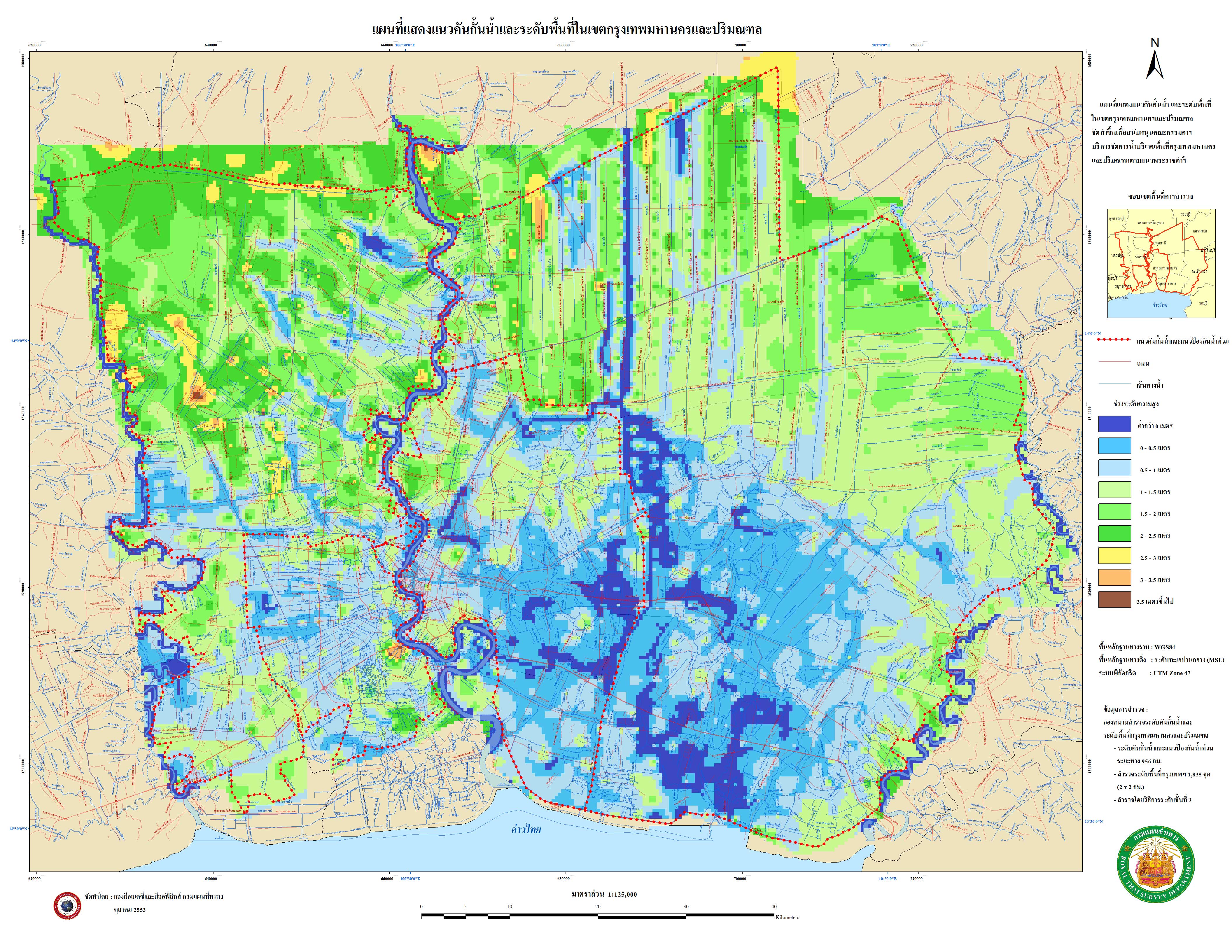
Here is a map of the waterway's in holland with elevation levels to give you any idea where they talking about.
The card does not mention the rather small Dutch rivers who have been present for many centuries now. E.g. De Beerze in the south of the Netherlands which btw. contains a much too small rope bridge at its famous Holy Mary Oak (early 15thcentury found in the river De Beerze). Currently during the last two decades De Beerze got almost as many artificially created windings as the famous road high in the mountains from Mea Sot to Umphang in Thailand has in a natural way, making nature lovers sitting on the back of a pickup truck vomit, and making the Dutch De Beerze crossing potential areas which are to be flooded (to be givenback to nature) in case of an emergency. It seems also Mother Nature vomits locally from time to time. A large capacitor for storage of water always needs a rather large area. The largest capacitor area available for flooding in the Netherlands is the Netherlands itself. When really large amounts of water need to be transported horizontally control of the speed of water transport becomes in my opinion more important than the total flooding area available. Currently all Dutch cities and villages already have water problems during a relative heavy rainfall (being rather small compared to rainfall in the northeast of Thailand).
I just can't remember when Hollands last monsoon rains were?
And when was the last there was melting water from the snow ice and gletchers coming from the north of thailand, not the rain in holland is a problem thats same as in thai with local rain in bkk the problem is the melting water down stream from tthe main rivers in combination with heavy rain fall in swiss, germany belgium and france and high tides by storm depresions.
-
The Dutch East India Company played a vital role in Ayutthaya's foreign trade from1605 until 1765
And at that time we already advise them to build there capitol on higher grounds.
But yea if you get a king named King Taksin Maharaj (King Taksin's achievements have caused to bestow on him the epithet "The Great".)
You can imagine what happen, so they build Bangkok started in 1767
And now waiting for the great Taksin for new great plans.
-
Water management will require years of investment, Dutch expert advises.
Shouldn't that read:
Water management will require years of corruption Dutch expert advises!!!!!
What ever they manage there will all way's be corruption but without any plan there will not be annything left to corrupt.
-
The japanese will do a great job protecting all there industrial estates and communities by building high wals and dikes around them connected with elevated roads to main sea ports and airport and leave all the rest to the thai to protect.
-
So by a storke of luck and the narrowest of margins inner BKK escapes, now wait for next years 1 in 1000 year floods to come.
its 1 in 25 years but your save for next years cause the 7 dry years will struck thailand.to be bone dry and crying for water
-
Water management will require years of investment... And some common sense... Let's hope they get at least the investment lined up
Maybe NOT. Probably the infrastructures are already there. Just requires one final touch to make a complete Integrated Water Resources Management. I hope this is really the case for Thailand.
There is no infrastructure if you talk about water manegement on the scale needed we not talk about klongs from a few meter wide or deep but about making rivers run smootly deeping it out and keep them that way.
To make canals from 50 meter wide and at least 10 meter deep making room for overflow of rivers make dikes around those rivers and canals from at least 3 meter high
-
Here is a map of the waterway's in holland with elevation levels to give you any idea where they talking about.
-
I'm on Pattanakahn 51, just off SriNakarin. Just looked off my balcony and can see the sois between Pattanakahn 51 and 53 are not flooding, but definetly getting wet from water coming up from the sewers. It's not deep at all, but the water is going down the sois at about a meter every 5 minutes - kind of like the blob of the 50's horror film. If it goes like this all night there will be build-up. None of the houses are sandbagged.
you mean here 12-14 Soi Pattanakarn 51 (Soi Floraville) Pattanakarn Road
-
have found a site with a chronicle photo impression from thai flood 2011 verry good
-
lad phrao 148 20cm water at 8pm this evening overflow from klong saen saep canal
-
Can anybody confirm on this flood map
just updated, water at mall Bangkapi and Ramkhamhaeng 54,56, 58, 58-1, 58-3, 58-5, 60, 60-1, and the lat Phrao
area around intersection thanon srinakarintara lat phrao
That update is contradicted by the traffic cam at the Nawamin/SeriThai/LadPrao intersection Traffy - Bang kapi
The map tends to exaggerate a bit. On several occations lately have I been driving arround areas without seeing anything but a lille wetness around an occational drain, just to come home and find out that I apparently had driven around in a totally flooded area according to that map.
thanx for the info and the traffy link can help a bit if realy water or not, think the map is still good cause mostly start with litle water out of drains and give a good oversight off the flood progress if you have better link to maps please post them.
-
Can anybody confirm on this flood map
just updated, water at mall Bangkapi and Ramkhamhaeng 54,56, 58, 58-1, 58-3, 58-5, 60, 60-1, and the lat Phrao
area around intersection thanon srinakarintara lat phrao
-
Seems a bit too obvious, but one of the arts of management, whether it be a company or a country, is delegation.
Delegate groundwater management itself to competent professional engineers and not leave it to unqualified, incompetent politicians. Likewise with long term planning.
There would still be ample opportunities for politicians to "participate" in construction projects. :jap:
Corruption will always be a problem but would be a lot less if they had a special independent department for water management with a longtime budget.
Based on foreign expert's rapports how to handle and solve flood and ground water.
And I am sure Bangkok will need it to survive with an average sinking of 2 a 3cm a year and a rising sea level from around 1 cm a year and a increasing rain fall in central Thailand
Hope this disaster open their eyes.
-
Just heard from one of our neighbours in Ram Inthra soi 69 that the water has gone down slightly today.
Mouth of the soi still mid shins, but further in, ankle depth.
However, Khu Bon Rd(Ram Inthra soi 71), still deep, but the large songtheaws and Army trucks running.
Apparently Khu Bon Soi 27 still has deep water. If scott1999 says 1 meter at Wat Khu Bon, then Khu Bon 27 should be similar.
This is puzzling. If it is going down in RI soi 69, then it should be going down in Khu Bon as well since the khlongs are connected.
think this is a matter of elevation differents the water in the klongs would be nearly same level but the water in the soi could be different cause the water from the higher soi flood to the lower soi meaning in first 1 get lower and in the last one get same or even higher water levels.
-
I looked through the earlier post and saw some mentions that Sunhumvit isn't flooded yet.
Can someone confirm that?
Is Sukhumvit still dry between Soi 4 and Soi Cowboi? (No, it's not about going to the bars)
Is the road from Swampi to Sukhumvit still passable by car?
Are the Banks and businesses near above mentioned Sukhumvit Sois still open? In particular Kosikorn bank near BTS Nana?
Would appreciate a quick and simple reply to my questions. I could probably find all the answers myself here, but I am currently offshore and with my internet speed here, it would take me days to finish searching.
Thanks!
sukhumvit is still dry no problem for go by car from swampi kasikorn bts nana is open some business are operating at lower level because many employe are stuck or operating in flooded area.
-
Good news indeed. However, water here in Supalaiburee Village Klong 4 is receding slowly 1 centimetre a day, still over metre deep in the soi (see attached snap taken outside our house 09.11.11.).
concidering the evaporation of water is between 2 a 3 cm a day actualy there is more water coming in then going out
-
Flood predictions expertise panel
There are some simple rules.
1. How many water can the combined rivers flow ofwater natural
2. How many water can they pump in the sea artificial
3. How many water evaporate natural
Ok that's easy or not.
1. What's the combined flood water surface in m2
2. What's the combined volume of the flood water in m3
3. What's the flood speeda minute rate in m3
Complicatingfactors.
1. Terrain elevation
2. Canals floating rates
3. Canals combined m3 factor
4. Artificial barriers
5. Changing weather conditions
So how we predict how severe the flood will be.
Not all the water will hit us in 1 time it will be slowly but it will come in portions.
It's like waves on the beach.
We have to predict how many water m3 with interval of 6 hours will hit us in conjunction with the high and low tides.
How many can flow in the sea and how many remain to flow on the land area.
Managing water is an art not many understand it's a complex business with long time fore casting vision to prevent flood like this.
Please be free to give your opinion maybe this Thai government and the ones to come and all of us will learn from it.
-
Thanks, and have to pass through Victory Monument? I wonder how that will be... I should really get my car to BKK (can park at my wife's work on Tiwanond road, which is still surprisingly dry.
think its not a big surprise tiwanond road is still dry look here http://bkkbaseface.files.wordpress.com/2011/10/bangkok_elevation_map_medium_resolution.jpg
elevationmap, not to sure where your wifes work is not hope in the blue area cause that can become a big lake
-
Water taken a d-tour around the big bag barrier BBB
As I see now water rising rapidly in klong saen Saep withflood reports in Ramkhamhaeng soi 53and 43-1( that are the lowest partsthere nearly 1 meter lower than the surrounding area )
-
Good report and it looks like the water is receding on the eastern side on Bangkok. The West and Rama II, well that is a different story.
hmm not think so this morning jump about 3 km from bang chan to bang kapi
[8/11,11.22] Ramkhamhaeng Soi 68 being overflowed
near bang kapi hua mak
-
If any body have updates about Flood level in the drainages system please we want to know if still rising where does all the water go.
cause for now it seems they are lucky with low tides and manege to pump most of it away from the effected area's so it not flood more then all ready did.
here in soi lat phrao 94 no increase in under ground drainage system in last 2 day.
-
scott1999, I hope you sleep well.
Thanks for those reports. If you could post up, while you are bored at work, on the situation in Khu Bon, my wife and I, would appreciate it. Thanks for soldiering on through the dangerous flood waters.
We would like to go home, but know that it is not possible yet. If Rama II gets flooded, then we are cut off completely out here in Ban Pong.
I heard something on the daily FROC broadcast this evening something about Rama II and the 340 through the west of BKK. Anybody catch that?
There was also something about using the Mae Khlong, the river running through Ratchburi province, for drainage.
as i understand they not have plans to protect those roads because they say its the natural way to sea!!!!
not understand to many of there policy want to pump muang dry and give up the only way going south
as i see they could protect it and still let the water flow if they build some improvisite bridges on key points.
the use of the mae klong is one of ther other useless ideas to manege water.
There is no way they can protect Rama II from flooding.
There is a canal that runs between the Tha Chin and Mae Khlong rivers.
Plenty of room for water in the Mae Khlong, I can tell you. It could take 2 meter extra easy.
yes it could but water is not running up hill so they need to pump the water up hill it not flood natural to the mae klong
and for protection of the rama II your probely right it was posible if they started 2 a 3 weeks ago
see the elevation map http://bkkbaseface.files.wordpress.com/2011/10/bangkok_elevation_map_medium_resolution.jpg and imagine where its blue they had to protect and made some extra bridges to let the water flow south it was possible
Wake Up Call
in ASEAN NOW Community Pub
Posted