

Route21
-
Posts
240 -
Joined
-
Last visited
Content Type
Events
Forums
Downloads
Quizzes
Gallery
Blogs
Posts posted by Route21
-
-
and when a young child takes the gun out and shoots somebody?...........
the dog will get moved to an inactive post for a couple of days.
Or maybe "tied to an inactive post"?
-
 2
2
-
-
Great news!
It looks like you are now much closer to a conclusion.
The only caveat I would have is that it's just possible that it may have been replaced at the time of the later ceremony, particularly if it was in a state of poor repair.
I've not yet had a chance to take a peek at your links, but I'll see if someone can help with the Thai document.
Regards
R21
-
I guess they both sat IQ and psychological tests.

Did the dog have to have a "Lab" test to qualify for the gun?

-
.... As Saraburi was the junction of the two major roads (first long distance roads) in Thailand suspect it would be at that junction so could be viewed by travelers on both routes.
The original junction has since been replaced by a major flyover that would have swallowed it completely, unless it was possibly saved and relocated, maybe directly under the flyover on it's completion. That would be easy for a local to spot.
My only concern over it being located at the Saraburi end would be that stretch was apparently completed first.
I would have thought that, politically, the monument wouldn't have been installed until the Korat section (and its funding) was complete. In which case, it would have had to be installed long after the Saraburi section was completed and would possibly favour a Korat end location?
R21
-
- Popular Post
- Popular Post
Poor fella, makes him a target and probably the first to be shot, great plan once again!!
Yep, great news.
Dog chases unarmed criminal, catches him securely by the wrist.
Criminal removes gun with free arm, kills dog and escapes!
Good idea, Batman!
R21
-
3
-
Hi Mike
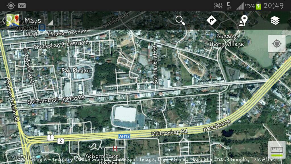
Just for the heck of it, to check out one of your basic assumptions, I asked Google maps to give me directions from Bangkok to the Nakhon Ratchasima (Korat) end of Route 2.
It came up with the route via Saraburi and Route 2. The distance was 258 kms (160 miles) and a time of 3 hrs 7 mins. Bear in mind that is on the current condition of the road and a modern car, it could still easily be a day trip from Bangkok. We would normlly set out at round 6 am for such a trip, as it's just starting to get light.
Also, bear in mind:
1. who would be most thankful for the road - Saraburi, where it would just increase the through traffic, or Korat, where it would provide faster access to markets in Bangkok for their produce?
2. wouldn't a monument most likely be erected at the finishing point?
3. where were they when the road was finally finished? - Korat.
Maybe someone from the Korat area, who had ignored the thread, thinking it related to the Saraburi end of the road, might now be able to help?
Best regards
R21
-
It's a very localised situation around our area.
A mate of mine's pond, on the brow of a hill, was drying up. He hired an excavator, on an hourly basis, and hit an aquafer at 10 metres down. He now has plenty of pond water for his fish/garden.
His neighbour, starting ~10ft lower, did the same but no water!
Around 10 years ago, I was quoted ~150k baht for a well, including a stainless downhole pump. As we weren't planning on moving out here at the time and the cost was too high we declined.
Regards
R21
-
Just a slight correction to my earlier post.
On reflection, a municipality official at the time would probably be a better bet. It was probably purchased as a "thank you" to the US for helping fund the project after completion. A young "official" is more likely to have been involved in/attended the actual ceremony rather than a young field engineer - plus you may be looking at a later date for the ceremony and hence a "currently" younger witness.
Also, it would possibly not have been handled through the engineers but "commisioned" either directly by the municipality or indirectly through the contractor from the local stone/monument masons (or their Thai equivalent).
Just a few thoughts that might help.
Regards
R21
-
1
-
-
Hi Mike
I don't know if you've seen it, but there's a short article on it in Wikipedia:
http://en.m.wikipedia.org/wiki/Mittraphap_Road#mw-mf-overlay
Regards
R21
-
Hi Mac
The problem that the OP had, I believe, is that he is currently in the States and wanted to know if anyone knew if it still existed and if so where.
I didn't start travelling through Saraburi till 2002, so my thoughts were just a stab in the dark that might have helped.
If it were at the Saraburi end and the flyover was built over the old turning then there's a possibilty it didn't survive the construction of the flyover.
I can't imagine a contractor in those days wanting to relocate the memories of a previous contractor's work to a "safe" location?
If the project started in 1954, i. e. 58 years ago, you would probably need to search for a government/municipality engineer in his late 70's.
I very much doubt if such a monument would be shown on the "construction" drawings because it wouldn't have been thought of at that stage - and the possibility of any "as-built" drawings either showing it (or even existing) is probably somewhat remote.
Is there anyone in the forum who might be driving, say, from Saraburi to Korat or even to Tesco's via the flyover, in the near future who might try and spot it for the OP?
Regards
R21
-
I agree that Thailand has a huge water management problem, but it's "huuuuge" coastline only serves to provide a huge amount of salt water.
Unless it can economically be desalinated and pumped to where it's needed, as it can be in the gulf countries (dictated by their economic situation), it's not available for washing or drinking.
One thing that they do in the gulf, that Thailand could possibly benefit from is using partially-treated sewerage water for irrigation purposes. But that involves expenditure on a proper segregated drainage collection system rather than using septic tanks and soakaways/ditches, where it's pot luck if and when, with clay soil, it makes it to the water table.
I also believe they should reserve a cetain portion of the available water for domestic, rather than agricultural use, as, at the moment, I believe, the vast majority of the water is used for farming and the domestic customer just gets what's left over, if any. Again, this needs investment in segregated water mains - domestic vs agricultural without even considering industrial use.
Trying to be constructive.
Regards
R21
-
Even Arab countries in the middle of the <deleted>*ing desert DO NOT have this kind of water supply problems that i.e Pattaya has.
Arab gulf countries, in general have had access to vast quantities of oil/gas. This fuels the large power stations they need to operate the huge numbers of A/C's they use.
Fresh, desalinated, sea water is a byproduct of the huge demand for electrical power.
There's also a fair number of underground aquafers.
In the 20 years I was associated with the gulf, 1 ltr of water was more expensive than 1 ltr of petrol.
There would probably be no shortage of water in Thailand if Thais were prepared to pay more for their water than for petrol (assuming all the profits were channelled back into water infrastructure!).
R21
-
Maybe this is the reason some Thais have kids!

And then again, maybe not.
Cattle represent an investment that's unlikely to end up as a liability!
:rolleyes:R21
-
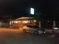
You mean that road name: Thanon Burakarm Kovit?
It wil be nice if you can make general Google maps pinpoints.
Yes, that's the road. I can see the wat on my android copy of Google maps, but it doesn't specifically identify the snooker hall.
Unfortunately, I'm not back off holiday for a few days and ny mate is touring and may not be back for another week, however, I'll see what I can do when he's back.
I'll probably end up with a jpg screenshot similar to the one below that shows the road and the wat.
Cheers!
R21
-
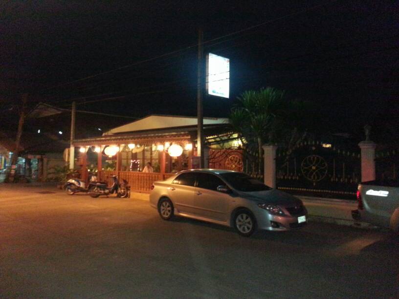
Here's a plccie.
That's a cola advert on their post.
Njoy
R21
-
A screenshot from Flight Track Free.

-
1
-
-
Years ago, I saw a flight tracker. But these are pretty awesome!!!!
Try "Flight Track free".
You can identify the flight number by entering the "from & to" locations and selecting the actual flight from a list of all current/upcoming flights that meet that criteria.
Once selected, you see the photo realistic plane flying over an excellent, zoomable Google satellite map, with the towns and coutries etc clearly labelled.
Below the map, it shows the flight number, the departure and ETA, together with the minutes early/late at each end.
Brill! What more could you want/need.
Cheers!
R21
-
You can also be 99.9999% sure that horse meat would taste better.
And would probably not be as tough as the local beef, that probably only arrives at the butchers if it died of old age (or by accident)!
Those who keep cattle round our way don't even bother milking the cows, as eating rice stubble every day doesn't promote good quality milk yields.

I could never understand the logic of keeping cattle here until someone said they bought them as an investment and liked to physically see their investment grow!
R21
-
If you buy beef in Thailand you can 99.9999% guarantee that it contains no horsemeat!


It'd be too darned expensive even if you could get it!
R21
-
There's quite a nice (indoor) clean, Thai restaurant now open in Na Chaliang. Ideal for a meal out with the wife/family.
Turn East at the (Siam Commercial Bank) traffic lights and its about the 3rd block down on the right hand side - just a little way after the clinic (LHS) & dentist's (RHS).
It's also very reasonably priced.
Regards
R21
PS May be able to post it on Google maps after tomorrow.
-
Cost of living's going up!
Price of wholemeal bread at Makro increased to 40 baht!
R21
-
You may have difficulty in getting a response from any TV members in Saraburi.
There have been recent reports of unacceptably high levels of dust pollution from the local quarries and related industries.
Maybe the local TV members have moved out!


Regards
R21
-
Yes, I was desperately looking for a street view.
We used to use the flyover to get some shopping in from Tesco on our way north from Don Muang/Swampy before we moved here and got our own Tesco & Big C in Phetchabun.
Regards
R21
-
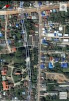
I know that the stretches closer to Korat were the last parts that were completed, so I believe that this marker was somewhere near or in Saraburi.
Although not from Saraburi, we have regularly passed through on the way up North.
Looking at the Google map, copy attached, if it's at the Saraburi end of Route 2 and still there, it's possibly on Sut Banthat (see Google screenshot), just North of the new flyover (AH12) as you enter Saraburi from Bangkok. It appears to be the "old road" before they built the flyover. (The track just immediately south of Sut Banthat is a "klong" or canal.)
If not there, it would probably have to be once the new flyover and the "old" road merge and you are back on the "old" Route 2.
Maybe someone living in/around Saraburi can spot it and give a more definitive answer.
Hope this helps
R21

-
1
-


Thai Police Issues Gun To Labrador
in Thailand News
Posted
No chance! Ain't life a bitch!