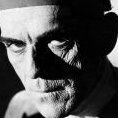
British comedian Bill Oddie, who became a household name through the BBC comedy series The Goodies before building a second career as a wildlife presenter and conservationist, has died aged 85. Comedy fame with The GoodiesOddie’s death was confirmed on Saturday by his agent, David Foster, who described him as a multi-talented entertainer whose work spanned comedy, broadcasting, writing, music and environmental campaigning. He first rose to prominence as one of the members of The Goodies, a comedy trio alongside Tim Brooke-Taylor and Graeme Garden. The group starred in the BBC series of the same name, which ran from 1970 to 1982 and became known for its unusual style of humour and inventive sketches. The programme helped establish Oddie as one of Britain’s best-known comedy performers, but his interests extended well beyond entertainment. From comedy to wildlifeOddie later turned his lifelong passion for birds and nature into a successful broadcasting career. He presented several BBC wildlife programmes, including Birding With Bill Oddie, Bill Oddie Goes Wild and Springwatch. His agent said that despite his celebrity status, Oddie was more concerned with encouraging people to appreciate and protect the natural world. “Bill was a multi-talented celebrity — wildlife presenter, broadcaster, comedian, writer, songwriter, musician and conservationist,” Foster said in a statement. “Yet it was never fame that he valued. Instead he encouraged us to respect and protect the environment.” Oddie also wrote several books about birds and wildlife, including Bill Oddie’s Little Black Bird Book, Birdwatching with Bill Oddie and Follow That Bird. Early career and legacyBorn in Rochdale, north-west England, in 1941, Oddie studied English literature at Pembroke College, Cambridge. During his time at university, he performed with the Cambridge Footlights, the renowned student comedy group that also featured future stars including John Cleese and Graham Chapman of Monty Python. His performances with the Footlights led to opportunities in London’s West End and on Broadway, eventually convincing him to leave behind plans to become an English teacher or work at a bird observatory. Oddie’s career later combined his two greatest passions: comedy and wildlife. He became a prominent voice for conservation and inspired generations of viewers to take an interest in nature. Join the discussion? 28 July 2026
View full article


Create an account or sign in to comment