

simon43
-
Posts
15,288 -
Joined
-
Last visited
-
Days Won
1
Content Type
Events
Forums
Downloads
Quizzes
Gallery
Blogs
Everything posted by simon43
-
 My walkie-talkie is rather low-powered. I did manage to make a contact via the ISS with a radio ham in China when I was in Laos as XW0LP. However, TBH chatting with other radio hams is a little boring for me. I prefer to receive the images sent by the ISS and some from the Russian cubesats. I don't know when ISS will next transmit SSTV pictures (they'll announce it beforehand). But on June 27th the Russian college cubesat UMKA-1 will transmit SSTV images of space-topic drawings submitted by young students across Russia. I asked one of the schools that I'm in contact with in Burma to submit a couple of drawings and I've sent these on to the space centre in Moscow - so I'm hopeful that one will be chosen for transmission by UMKA-1 🙂 Sadly (for me), all passes by that cubesat on June 27th are at low elevation at my location, but I'll try to receive something! SSTV is an analogue signal, so even a weak signal can result in a visible image.
 -
"I think I have seen mention of the Hydrogen line when reading something years ago. I don't know what it is though" All atoms in space vibrate a little and this releases a small amount of electromagnetic energy at a specific frequency for each element. For hydrogen, this is about 1420MHz. Since stars consist mostly of hydrogen, this element is the easiest energy to detect, especially if one points the antenna straight up and averages the signal over a few hours as the Milky Way passes overhead (as the Earth rotates). The video I attached shows the Hydrogen energy 'blip' around 1420 MHz. The Earth is is superimposed by the star application software as the green dot on the right. As you run the video, you'll see the blip increase in size as the MW (ie more stars) pass over the Earth, and then reduce in amplitude as my antenna is pointing at an area of space with few stars. Since this is radio astronomy, one can also perform this experiment in the day time. The 'hash' on my specral display is probably interference from a nearby phone mast. Having received the hydrogen line energy blip, could I look for water vapor energy or oxygen or..... No :(, because the frequency at which these elements emit energy is far higher, and I have no equipment to receive it. And of course it's far weaker than the amount of hydrogen - so I would need a very big antenna dish!
-
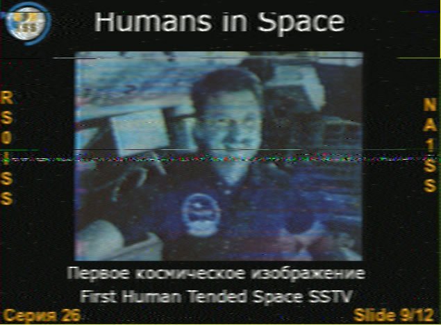
Another post about interesting signals from space 🙂 The International Space Station (ISS) occasionally transmits SSTV (Slow Scan TV) images on a 2 metre band VHF frequency. I have received these images on previous occasions and I show one below as an example. But the ISS also has a 'cross-band repeater' on board, whereby licenced radio hams can transmit up to the ISS on a VHF frequency, and their signal is retransmitted in real-time back down to Earth on a UHF frequency. Occasionally, the astronauts on the ISS will also chat with the radio ham 🙂 I noted that the ISS was going to pass over my location at the ungodly hour of 3.10am last night. So I decided to see if I could contact another radio amateur via this repeater. I set up my equipment using a small 'walkie-talki' as the uplink transmitter and monitoring the UHF downlink frequency using my SDR dongle and software. Ideally, I should move my UHF yagi antenna to follow the ISS as it moves across the sky above me, but this was impossible, since I also had to use my walkie-talkie and monitor my laptop for received signals (I have to manually rotate/swing the antenna mast - I have no Az/El rotator).. So I pointed my antenna sort of mid-pass.... Anyway, as the ISS came over me, indeed I heard another radio ham who had also got out of bed like me! This was Liu Cheung in Hong-Kong, callsign VR2WAZ, and I attach a short audio recording of his signal that was being relayed by ISS 🙂 Unfortunately, although I called back, my signal was quite weak, but the ISS relayed it. You can hear Liu say "QRZ" which is a short code for "who was that?" so he heard my signal but the ISS was already at a low angle and moving northwards over China. (AN doesn't support mp3 files so I saved it as a blank mp4) VR2WAZ.mp4 BTW, for anyone not interested in space comms, it must be more exciting to watch paint dry... 🙂
-
That's a real-time sweep and yes, the signal peak is about -112, but the S/N of 16 is more than adequate. Averaged display from multiple sweeps is used to receive/display the Hydrogen line signal. I built an antenna to do this in Laos a few years ago. and this is a video of that signal with the Milky Way superimposed. That measurement was made over several hours, so as the MW passes overhead, the amplitude of the hydrogen line increases. HYDROGEN-LINE.mp4

-
Reviving this old thread: I'm planning to buy one of these: https://www.lazada.co.th/products/pdp-i4866947009.html It's a pedal-assisted electric tricycle, 25km/hr and 45km range when only using the battery/motor and of course far greater range when pedalling only (for exercise), or part-pedalling. 16,000 baht..., probably street legal because of the pedals...
-
Well, unlimited so long as the bank has the cash 🙂 I once tried to withdraw 3 million baht, but the bank didn't have enough cash to give me that amount!
-
I have to go to Bangkok for a week and need to leave my car near the airport. I don't think the airport itself has long-term car parking. Is there a company near to the airport which offers long-term, secure car parking? Thanks.
-
A virus is dead cell debris??!! Go back to school! A virus is not and never was a living organism. It is a pathogen that 'hides' in living cells and replicates when the cell replicates.
-
Irrelevant for me - I had Astra Zenica vaccine donated to Laos - that vaccine uses an adenovirus vector
-
Since I am older and have compromised lungs, I was happy to have 2 covid shots while I was living in Laos during the covid period. These shots helped my immune system to 'recognise' the Covid virus (all viruses have a different and recognisable shape/structure). I am fully aware that a vaccination does not stop one becoming infected with the virus, but that the symptoms of that virus should be greatly diminished, compared to those who have not been vaccinated. Indeed, after relocating back to Thailand, I did get Covid, (according to the 7/11 test kits). I had a mild fever for only 1 day and then recovered and subsequently tested negative. I'm grateful that I had been vaccinated in Laos.
-
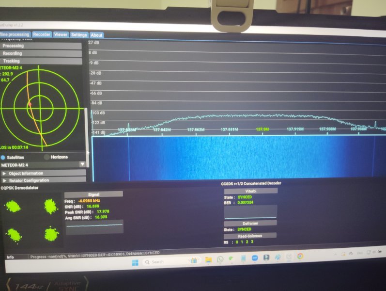
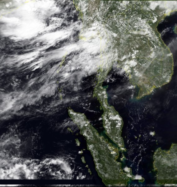
Since I only have a few science lessons to teach this evening, I'm on a roll with satellite signals! I switch over from my dish antenna to a 3-element VHF beam antenna, designed to receive the NOAA and Meteor weather satellite signals. The Russian bird Meteor M2-4 is coming over, so I configure Satdump to receive and process the signal. Here's the screen-grab as the data was being received from the satellite. and after Satdump has completed processing of that data, I have various image files, with one shown below: Meteor transmits image data in a digital mode, so the quality of these images is better than the analogue NOAA satellites. But note the horizontal black band near the bottom of the image! That's due to some bug on the satellite itself...
-
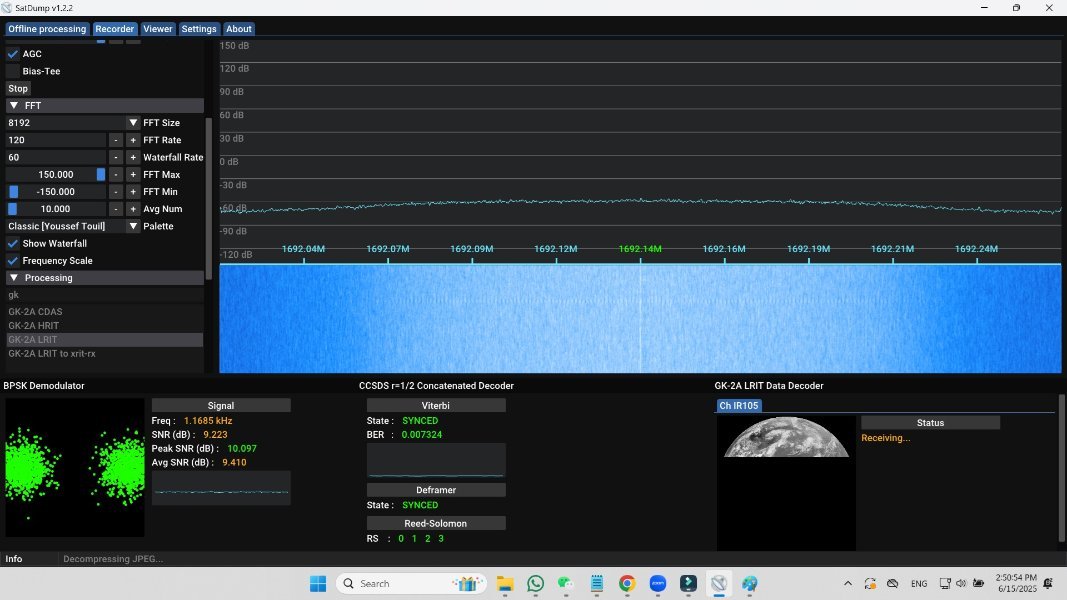
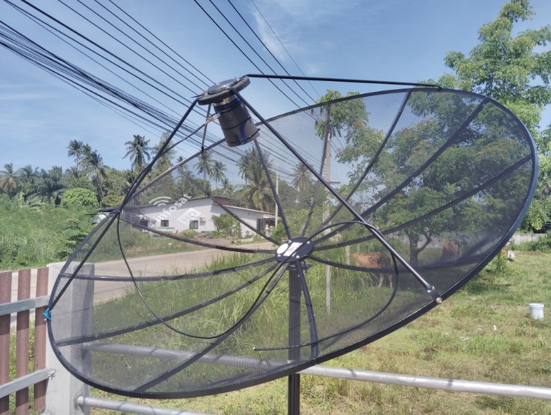
Having finally got my big dish to receive images from the south Korean geostationary satellite, I tidied everything up by running the coaxial cable from the dish to my laptop in my room. From previous experience, I knew that the signal received at the dish would be degraded by the cable losses, such that the Satdump processing software would no longer have sufficient signal to work with. This proved true, but fortuously my new 40dB LNA blocks arrived by post from China. With one of these placed in the cable run at the dish end, I had a 10dB S/N (signal-to-noise) ratio at my laptop. (The image shows about 9dB, because it's the middle of the day and the Sun is shining directly onto my dish and LNA block, degrading the S/N). The images are transmitted every 10 minutes and are sent as 12 horizontal slices of the Earth. I use these infrared images to create (using post-processing software called Sanchez), to add the country overlay/underlay. My screen grab was made after a few slices had been received,
-
There is nothing to discuss. I'm a scientist, trained for 7 years in critical thinking and the Scientific Method. Granted, although I teach all streams of science to my young students, I'm not a medical doctor. But I understand enough about virology and the immune system to know when someone is talking total bolox 🙂
-
old enough to have senile dementia.....
-
Lol, I already had the poo yai bahn here last week to ask about my antennas 🙂 He went away quite happy after I showed him my Thai ham radio licence and we chatted about weather satellites. I used to design equipment for various satellite payloads and ground station projects, Skynet, Envisat etc, but I left the profession when I moved to south-east Asia 23 years ago. since then it's just for fun...
-
@Satcommlee, impressive line up of equipment. What signals/frequencies do you hope to receive? @IssanT, the easiest system for receiving weather maps that include indication of rain intensity are the weather maps from NOAA-15 and NOAA-19 low-earth orbit weather satellites (NOAA-18 being 'dead' since 6th June..). To receive these images you need: - a suitable antenna You generally have to make this 'cos Thai Customs see 'red' if any package arrives from overseas with the word 'antenna' in the description. This is a simple omni-directional antenna that I've built a few times using strong chopsticks and blue plastic water pipe and stiff wire: https://www.instructables.com/NOAA-Satellite-Signals-with-a-PVC-QFH-Antenna-and-/ - some RG6 satellite TV cable to connect your antenna to your SDR 'dongle' receiver - The dongle receiver, typically supplied from RTL SDR v4 for about $33 USD (shipped quickly from China, no Customs import issues) https://www.rtl-sdr.com/product/rtl-sdr-blog-v4-r828d-rtl2832u-1ppm-tcxo-sma-software-defined-radio-dongle-only/ - a Windows computer running the free 'Satdump' software to process the received data and to produce the weather image files https://github.com/SatDump/SatDump/releases/download/1.2.2/SatDump-Windows_x64_Installer.exe - F and F-to-SMS connectors etc. Satdump, when installed and configured, will show you the times when the satellites pass over your location, and it can be configured to automatically receive/decode the signals. The 'whole world' images (well, all of one side of the Earth) that I showed are received using a large dish antenna system. That's more tricky to set up but I've set up this kind of system in 4 different locations over the past few years, including a few days ago at my home in south Thailand. I can receive whole-world images sent every 10 minutes by the GK-2A satellite from south Korea. I also enjoy receiving the data signals from Russian college 'cubesats'. This morning, one of these (UMKA-1) transmitted digital data from their space telescope of an image of the stars. (They usually transmit analog SSTV images, but this was a large digital data packet). Although I could receive this data, the signal was a little weak, so I couldn't decode most of it... better luck next time. Remember that some satellite signals are analog and some are digital. Analog signals, such as from the NOAA weather satellites and ISS and Russian cubesat SSTV images degrade 'gracefully' when the signal gets weaker, whilst digital signals are either there or not there, and no in-between!
-
Crime Fake Russian Doctor Arrested in Phuket for Illegal Medical Practice
simon43 replied to Georgealbert's topic in Phuket News
Probably botox or anti-lardbucket injections...- 58 replies
-
- 13
-

-

-

-

-
^^^ I use a kind of LoRa mesh with my shortwave transceiver. It'a system called Winlink (winlink.org), which allows those in remote regions, especially at sea, to send/receive emails, navigational maps etc. The sailing boat automatically establishes a radio link with my station in Thailand and I either connect them to my own internet connection, or if my internet is down, then my radio transceiver automatically establishes a 'relay' connection to the next Winlink ground station, which for me is in Taiwan or Reunion Island. I've used this system for many years, allowing sailing boats in the southern Indian ocean who don't possess satellite comms equipment, (or it's too expensive to use!), to check their emails, keep in contact with family etc.

-
^^^ Lol true. When I lived in Burma, my GPS on my phone often went crazy because it was being jammed by the junta...
-
I finally got my 'big-dish' system working to receive images from the geostationary weather satellites 🙂 These satellites sit in the geostationary orbit, about 50,000 km out in space. Satellites in this orbit revolve around the Earth at the same velocity so that the satellite 'keeps pace' with the Earth and therefore is always in the same position in the sky above you. So this orbit is used especially for satellite TV, internet satellites (not the new starlink system), and weather satellies! I had previously received images from these geostationary weather satellites, but I was always surprised at how weak the signal was, especially using such a large dish. This time I went through my system design parameters and discovered that my feedhorn which receives the focussed signal from the satellite had the wrong dimensions! Investigation proved that the online calculator which I used to obtain the feedhorn dimesions had an error in its calculations.... duh! So I remade my feedhorn with the correct dimensions, mounted it on my dish and was rewarded with a signal from GK-2A, which is a weather satellite of South Korea. Here's my basic receiving system: Satdump software processed the data into a visible image, and I then added colour to my infrared image using Sanchez - another free software application. ... and the result is.....

-
Since it's sent on shortwave, where the signal bandwidth is far smaller than VHF etc, the resolution is very low. It takes 20 minutes to transmit one map. I don't know why these WEFAX stations continue to operate.... For NOAA: Good to see that the overlay map is showing the correct region 🙂 NOAA-15 has a weaker signal than NOAA-19, so try to repeat with a high pass from NOAA-19. Of course, at the beginning and end of the pass, the signal will fade out but the software will still create the country overlay. You can set Satdump to delete these top/bottom regions automatically. Next, you can add a passive reflector or director to your antenna. This should be a single length of metal wire, taped to a bamboo support and positioned parallel to the dipole element, about 55cm behind or in front of that dipole element, (depending on whether it is a reflector or director - either is suitable). If a director, then its overall length should be 5% shorter than the overall dipole length, and if a reflector, it should be 5% longer. Then aim that 2-element antenna array straight up to the sky. I manually move my antenna to point it at the satellite as it passes over me, but fixing it straight up at 90 degrees will capture everything but the lowest elevation positions, where the satellite signal will be the weakest anyway. My 137 MHz is 3-elements, a driven element, a reflector and a director. (In previous photos, you can also see my 70cms antenna on the same boom - that had 7 elements and I added 4 more).
-
You just caught your wife cheating on you, again...
simon43 replied to SoCal1990's topic in ASEAN NOW Community Pub
For me, there was never an 'again'. She cheated once and we were down the government office next day to divorce... -
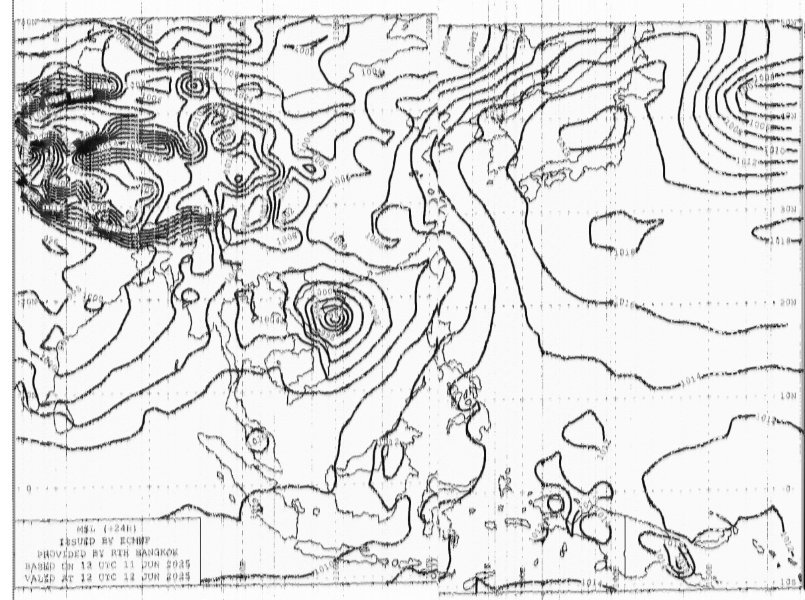
Before weather satellites existed, weather reports and maps were sent out using shortwave radio, mostly intended for ships at sea. This was called WEFAX and it would take about 20 minutes to receive one map of the region's weather, indicating high and low pressure areas, so that ships could avoid storms. Most of the WEFAX transmitting stations closed down years ago, but some still operate, including station HSW64 in Bangkok, which sends out these weather maps and shipping forecast throughout the day (and night) on the shortwave frequency of 7395KHz USB, using a 3 Kilowatt transmitter. The signal is quite strong on my radio in south Thailand, and with free decoding software from a company called Black Cat Software, I received this '24 hour surface prognosis' map just now. Even with a strong signal, the resolution of the map is far below what can be received from weather satellites. Why does HSW64 still broadcast these maps? No idea! Perhaps it will finally retire from service when the meteologist who creates the maps also retires... This is a link to list of WEFAX stations that still operate. Apart from Bangkok, I have also received maps from stations in China and Japan. https://www.weather.gov/media/marine/rfax.pdf
-
Moving a family to Pattaya from Bangkok thoughts?
simon43 replied to DonniePeverley's topic in Pattaya
I have a condo over the hill from Pattaya at Jomtien Beach, very much a family location. -
Merely reporting the weather in my area.....
simon43 replied to GammaGlobulin's topic in ASEAN NOW Community Pub
To avoid cluttering up GG's weather thread, I have created a new thread in the Sports and Hobbies subforum, for posting and discussing about space news, satellites, ISS, interesting signals and so on 🙂 The thread is here: https://aseannow.com/topic/1363409-radio-comms-hobby-weather-satellite-and-iss-pictures-shortwave-radio-signals-space-news/
