.png.3b3332cc2256ad0edbc2fe9404feeef0.png)


RidersCorner
-
Posts
222 -
Joined
-
Last visited
Content Type
Profiles
Forums
Downloads
Posts posted by RidersCorner
-
-
Winnie- This guy has done a great job of his bungalows (especially this one), if you want to get away from it all, its the perfect location and a 90 minute ride from Chiang Mai city
Nice! I like the bathroom up on the main sleeping area and not below on the ground level, AND that it has some kind of roof window making it nice and bright. I like wooden houses but don't like where the bathroom usually ends up; (some dank, dark place below).
-
Samoeng Farm Bungalows
A gap in the rain, so we took a quick ride out to Samoeng, west of Chiang Mai city

Herman has a German friend who lives in samoeng and told me he had some well hidden, private bungalows, so we went and had a look. This one 500 bht a night very private
Clean new room inside
Nice new bathroom - always nice to find (can be scary here)
Beautiful unspoiled view from the bungalow
2 other bungalows here has for rent for 300 bht each
Niko's house who owns the Bungalows
Gps co-ords of the Samoeng Farm Bungalows
18 deg 50 44.1 N
098deg 43 39.6 E
More info on Bungalows and the Samoeng area here:
http://rideasia.net/...alows-t897.html
Map of where the Samoeng Farm bungalows are located in Samoeng is below, the last left turn is a small unmade dirt trail, big enough for a pickup.
Map copyright © www.RideAsia.net
-
Interesting - Thankyou
Thanks for sharing.
It would be good to see more webcams of Chiang Mai.
I have seen them before but cant find the URL now, seems they only release to the public if and when they want to.
-
Glad to hear you're ok Dave, was thinking about you when I looked down that road from the Narawat bridge!
I've got a meter just outside my office window. The water is going down. Not quite as fast as it went up but it is at about the 2-3 pm level of a couple of days ago.
How's the road outside and will you be able to open today?
We are cleaned up and ready to go but there is still water in the street. The Duke's will be open in the Night Bazaar but not at the river location tonight.
-
It's hosted in the USA, so that piece of image data has to go to the USA and back again. Seems the upload here didn't like that & would freeze up, so we gave up and went to a 10 second refresh. Still interested to see these other webcams in teh Chinag Mai region.
saw your older posts regarding bandwidth at another site... this really should NOT be an issue for a low resolution picture (11kb) to be updated every 2 seconds or more often than that... perhaps it's an issue with hosting?
-
Justcruisin - can you give us the web URL's of the other webcams in Chiang Mai? will be interesting to see if they are in flood areas, I've looked on the net and can't find any other webcams
What is the web site where can see these webcams?
A lot of live webcams in CM actually, all run by the roads department on most of the major intersections.
-
where is it ?
Map of the location below:
Also GPS co-ords and address in the link below:
-
I just received my Garmin Montana 600 series (650) & it's a amazing machine .... I've had about 10 different Garmin GPS's in the past & this unit is superb. On Amazon around USD$ 480.
You can read all about it here to save me re-typing it
http://rideasia.net/forum/garmin-montana-650-gps-t872.html
The Nuvi's are ok but don't record tracks. The garmin 60 csx which can be bought for around USD$260 on Amazon is a fantastic mapping GPS.... The replacement 62 series is great too.
-
Newly constructed road data all included on this Laos GPS map
-
-
-
NEWS RELEASE -- The most detailed Laos GPS map in the world! 250,000 Km of map data collection & 8 years of work
All details are in the below website link:
EDITORIAL BRIEF: The ultimate, most up-to-date, GPS map of Laos has been produced and released for consumer use.
ULTIMATE GPS MAP OF LAOS RELEASED
For Immediate Release: April 12th, 2011
(Chiang Mai, Thailand): Driven By Adventure company ("DBAdv") has announced the release for general public use the most advanced GPS map of the South East Asia country of Laos. The result of over eight years of continuous data collection, the just released ULTIMATE LAOS GPS MAP from "DBAdv" has in excess of 50,000 points of interest for the user, twice the data of any former GPS maps.
The new and unique GPS map includes all primary roads, dirt tracks, and trails throughout Laos. Included in the data are gas stations, accommodations, mining sites, UXO locations, and Point of Interest tourist destinations. Some of the routes and destinations were so remote they could only be surveyed by use of highly modified off-road motorcycles. None of the data on the "DBAdv" ULTIMATE LAOS GPS MAP was gathered from external sources. For detailed information go to http://www.laosgpsmap.com
The ULTIMATE LAOS GPS MAP is physically available for purchase on a SD memory card for 1,500 Thai Baht or $50.00 (USD) at the Rider's Corner Bar & Restaurant, Chiang Mai (location link Riders Corner Bar & Restaurant location link) , Thailand, located in the heart of Chiang Mai, Thailand: http://www.laosgpsmap.com/purchase
The Driven by Adventure company is dedicated to providing quality, up-to-date, detailed surveys and GPS services throughout South East Asia. Their ULTIMATE LAOS GPS MAP has been hailed as "The best GPS, Internet or physical map available, by near or far!"
Explore the legendary “Ho Chi Minh Trail Map” including:
- Historical battle areas
- Sam Missile Sites
- Infiltration Routes
- Original trail network
- Primitive footpaths
- Modern roads
Secret mission areas including:
- Doghouse
- The Chokes
- Oscar 8
-
A printed version we've called the " North Thailand Road & Off-Road Map" is currently being printed in Bangkok & contains the exact same data as the North Thailand Off-Road & Tarmac GPS map, this should be available for sale in about 2 weeks. Retail price will be 180 bht, all profits from printed map sales (printed on waterproof paper) will be donated to charities within Thailand.
New release below:
The RideAsia.net North Thailand Road & Off-Road Map
by KTMphil » Wed Aug 24, 2011 3:33 pm The RideAsia.net North Thailand Road & Off-Road Printed Map
After 1,000's of hours of work & a multitude of unique off-road track contributions from many generous, enthusiastic rider's in the north Thailand area, we are pleased to announced that the completion of the "RideAsia.net North Thailand Road & Off-Road printed map".
This is the most up-to-date & unique map of north Thailand, containing all the latest roads & off-road track and trails not on ANY other map of north Thailand, nothing comes close.
The waterproof plastic map is currently being printed and will retail for 180 Bht - all profits from map sales will be given to various charities. Purchase inquires should be made to Somthawin Gibbins at Rider's Corner Bar & Restaurant, Chiang Mai, Thailand at the location in the link below :
http://www.riderscor...ation_biker_bar
We currently have large (79cm X 79cm) wall mount "North Thailand Road & Off-Road Maps" for sale, with eyelets in each corner, on indestructible vinyl. They can even be mounted outside in the rain as they are completely waterproof.
These are for sale for 750 bht. They cost 600 Bht to print, 150 Bht from each map will be donated to various charities in the region. We have received a great deal of interest these large vinyl wall maps in the first day of release, the printed maps that will retail for 180 Bht will follow shortly.
A photo of the Vinyl waterproof 79cm X 79 cm wall mount "North Thailand Road & Off-Road map" is below, actual maps can be viewed at Joes Bike Team, Chiang Mai (download/file.php?id=980) , Tony's Big Bike Rentals in Chiang Mai (http://www.chiangmai...cle-rental.com/), C & P bikes, Chiang Mai (download/file.php?id=1542)
Reverse side of the "North Thailand Road & Off-Road " printed map
This will be available for purchase at any of the SE-ED bookshops in most shopping malls in Thailand or can be purchased in about 2 weeks time from the Rider's Corner Bar & Restaurant, Chiang Mai, Location in the link below:
-
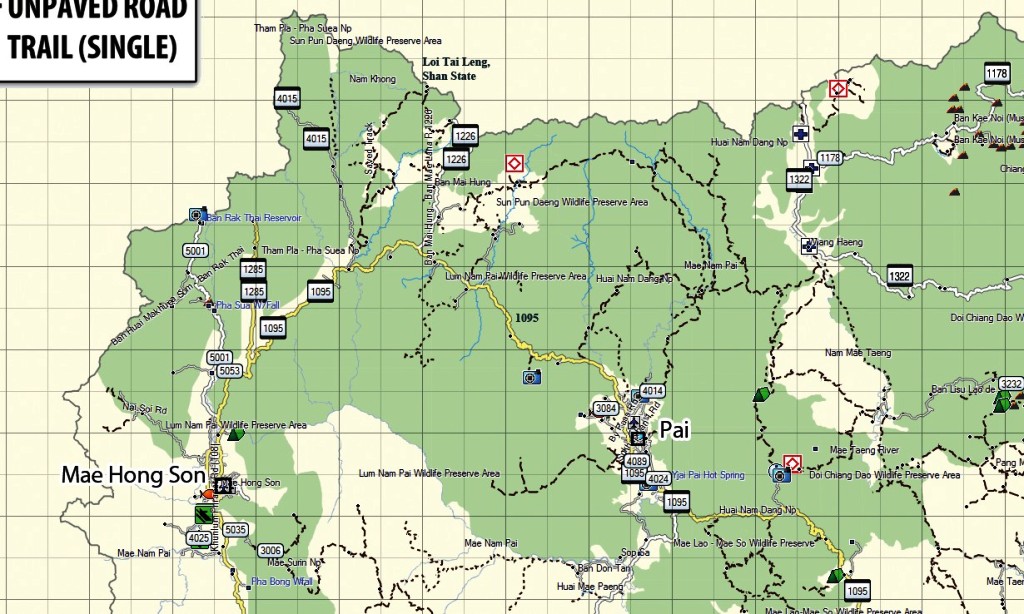
North Thailand Off-Road & Tarmac GPS Map
This is the undisputed, best, most up-to-date GPS map of north Thailand available. Below is an actual cropped piece of the north Thailand Off-Road & Tarmac GPS Map.
This is a detailed Garmin GPS map that provides current and accurate information about northern Thailand. It was developed for use by tourists, travelers, and locals to explore this beautiful and challenging part of the country.
* Extremely accurate coverage of highways, roads, streets, unpaved roads, and tracks
* Complete coverage of highways and major roads
* Detailed information about legendary Golden Triangle rides: Mae Hong Son Loop and and the Samoeng Loop
* Boundaries and trails inside of National Parks
* Many Points of Interests (POIs) of accommodations, airports, historic sites, waterfalls, and other picturesque locations
* Road information differentiates between types of expected road surface
* Offroad tracks made up from contributions from many local riders
* Routes for 4x4 and dirt bike exploration
Coverage includes:
* Chiang Mai
* Doi Suthep
* Samoeng
* Fang
* Doi Mae Salong
* Chiang Rai
* Mae Hong Son
* Pia
* Chiang Doa
* Udon Thani
* Mae La Noi
* Mae Sarieng
* Mae Sot
* Hot
* Mae Chaem
For more information or to purchase please visit the website below:
http://rideasia.net/forum/new-north-thailand-detailed-dirt-and-tarmac-gps-map-t7.html
or call Somthawin Gibbins on +66 (0) 870481787. The price is 900 baht.
-
Thanks Barry
We Would like to welcome Riders Corner as a sponsor to Thaivisa.
www.riderscorner.net
-
muchogra,
Nice to hear, thank you - Hope to see you again soon.
Both Phillip and Som are nice in addition to being handsome and pretty respectively. The younger helper from Chaiyapun is also friendly and cheerful. Though I like the fish and chip slightly better, both in taste and price, at Gecko than Riders Club I prefer going to the latter for the friendlier environment.
-
Unlocked now!
Thanks for the kind words Ringo, we do our best to help all the of the people that come through Chiang Mai, seeing as we do a great deal of adventure motorcycle touring the the Asian region.
The owner is a nice guy with good food and generous with information about biking in Northern Thailand.
-
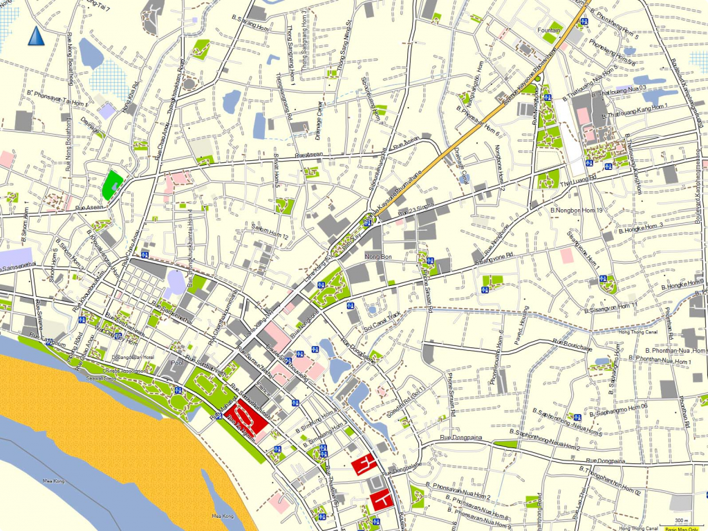
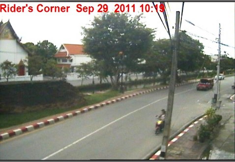
At Rider's Corner Bar & Restaurant, on the north east corner of the moat square (Moon Muang rd / Sriphum rd corner) in Chiang Mai, we've installed as far as we know, the only live webcam in Chiang Mai.
Fortunately, the land is high here, so no floods recorded on the webcam! Because of the small upload bandwidth it is impossible to stream video here, the best that the bandwidth can manage is a 10 second picture refresh.
Link to the webcam is below:
This is what the webcam image looks like below (click the link above to get to the live webcam image)
We had a power cut with the floods last nifgt ...the webcam has been recycled and is live again.
-
This morning next to the Narawat Bridge
TV news station camera's
-
River height 3 hours ago 4.52 meters
-
Sandbag preparations at the U.S Consulate
-
Narawat bridge
-
2 hours ago
one more
and another
lots more over on RideAsia DOT net ---- not allowed to post links here ---Phil
-
Dave,
The Mae-Mhae Orphanage School is one of the charities we are considering donating to, from the profits of the sale of the new "North Thailand Road & Off-Road" printed map. All profits from the sale of this map product will be donated to various charities in the SE Asia region. I'm sure all of us would be interested in your findings and decisions on donating to this charity.
Apparently I got the GPS coordinates correct....did you see them?
Yes, I posted a reply earlier. They are close enough to find the village on my map. I will find the school easy enough from there.
Here is the edited version of what was sent to you. Good information.
Mae-Mhae Orphanage School
1. Established in 1959 (Government School)
2. Transform to be Orphanage School in 2002 – Drugs Fighting at Burmese Frontier
3. Jong started to support this Orphanage School in May 2006.
About School:-
1. Teacher from Government 7 people.
2. Teacher Assistant 2 people.. (1 Man, 1 Women)-
Salary for them is @ 6,000 Baht/ month (Now is running out budget to pay for them)-
A teacher assistant have to stay with children for 24 hrs. at the orphanage school. .
3. Education System:- Government System
4. School areas is 3 Rai 3 Ngan 9 Sqw. (Belong to government and forest department)
5. Now the government pay for children s 10 Baht per person per day. But only 200 days each year.
6. Average ages of the orphans is between 3 - 17 years old.
The Orphans:-
1. Boys 52
2. Girls 67
Total 119
They are from family status:-
1. No parents (Homeless) 262.
2. Mum or Dad divorced/ passaway 383. Poor families 55
All orphans are:-
1. Lisu Tribe 82
2. Lahu Tribe 12
3. Burmese, Palong and Hmong 25
Where are they live?
4. Paksam Village, A.Wianghang (Burmese frontier) about 230 kms. from school. Take 10 hrs by car to the village.
5. Lawu Village about 180 kms. from school. Take 8 hrs. by car to the village.
6. San Pa Kia Village about 80 kms. from school.
7. Doi Sam Muen, T.Muangkong about 94 kms. from school.
8. Muser – Mae Ao Nai Village about 28 kms. from school. Take 2 hrs. by car to the village.
9. Muser – Baan Pa Lo about 27 kms. from school. Take 2 hrs. to the village.
10. ang Dang Village about 31 kms. from school.
About Identity Cards:-
1. Green Cards – Hilltribes (Legal) 42
2. No Cards (Illegal) 77


Samoeng Farm Bungalows
in Chiang Mai
Posted · Edited by RidersCorner
It's right on the outskirt of the town, just far enough away to be private, it's not in a forest area, sort of on the side of a rice field
Below is a photo of the entrance gate to Sameong Farm Bungalows. Im told Niko's Thai wife is an excellent cook and will cook for you