

T_Dog
-
Posts
4,212 -
Joined
-
Last visited
Content Type
Events
Forums
Downloads
Quizzes
Gallery
Blogs
Posts posted by T_Dog
-
-
Hourly report is good: Peak at 4.87 at midnight, it's been going down since then. San Sai is below critical for the first time at 6:00 am!! It's at 3.99, critical level is 4.00
Maybe the ping will be below critical at noon today?! Either way it should go down a lot.
Yes, that is good news. And the flow rates are promising. 400 cubic meters a second coming in from upstream and roughly twice that going past Narrawat Bridge. It will take a few days for all the water to drain though as the flooding covers a lot of area.
I am headed up the Mae Taeng River for a bike ride and hope to get some photos on the flow from up there.
-
Checked with another TV member who lives near the Kuang River (coming from the Doi Saket Dam) and apparently it joins the Ping near Lamphun or below Chiang Mai city. Most of last night's city flood surge came from the Mae Taeng River which was very very high yesterday morning due to downpours up in the mountains and possibly due to the canal flow diversion being dropped. There were no abnormal releases from Mae Ngat Dam which is not full.
-
Interesting...I drove all the way from Mae Rim to Hang Dong today,by the way of #107-Klong Rd,Airport,Hang Dong Rd...everything very dry,even the klong itself almost empty ??!! Can anybody explain that?
BTW,my place Ban Korovit II in Sanpong got flooded some(3-6"),but the neighbours got at least 2-3 feet.Came back around 5:30pm and it dried out some...I wander if it's gonna happened again tonight...This is only the 2nd time since 2005.
Yes, the canal has a very low flow. I THINK it is to avoid flooding in the Hang Dong and San Patong area that got hit hard in 2005.
-
Here is the statement George posted on another thread. I would be curious to know if anyone in the Doi Saket area could let us know what the outflow is like from Mae Kwang Dam.
-
Meadish,.... Mae Ngat Dam collects water only from the mountains and the valley up toward Phrao. It is not very full at all. The Ping River runs through Chiang Dao, Ban Pao, past HWY 1323 as it passes near Mae Ngat Dam and joins with the Maetaeng River in Maetaeng. Mae Ngat's currently nominal flow joins in just above HWY 1323.
The Maetaeng river is running very high from downpours in the mountains last night. The Ping River is slowly receding. Later, water from the Mae Kwang Dam in Doi Saket joins the Ping near Sansai I believe. Not sure exactly how Mae Kwang Dam's water enters in but it is worth checking out with the release statements that the government has published.
-
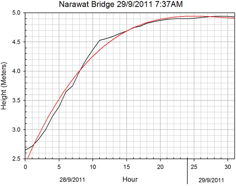
Updated my graph with current data for the curious.

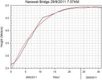
Good graph Tywais.
Also for the curious, here are what the times for the Ping River flood crest looked like yesterday:
Ban Pao to Chiang Mai: 24 hours
Highway 1323 to Chiang Mai: 18 hours
Note that this excludes any consideration of the inflow of the Mae Taeng River which is downstream from the points above.
-
Just saw this alert for later this week:
Right now the Ping River valley is kilometers across with water from Mae Taeng to Chiang Mai. Let's hope the whole basin gets a chance to drain before tropical storm Nesat comes through. Best wishes to all of you in Chiang Mai dealing with the floods.
-
Any reports of the depth of water in front of Pantip Plaza on Chang Klan Road this morning?
-
Guys , was playing with the system and got a link that show a few photo of the flood meter
i upload it on facebook . http://www.facebook.com/SiamGet
the link is form
http://hydrology.rid.go.th/wmsc/cctvrid1.php
but i suggest we don;t flood the server and usefacebook or other server for it .. cos if the server can't handle the traffic it might crash and we are out of info
i suspect that the other update server crashes and is not able to handle the flux of traffic for us checking every few min .
I agree Ta 22.... that site was suggested to me about an hour ago and I have been following the updates and good news.... it seems to have risen only about .02 in the past hour. Surely hope so..... could really use a drop over the next few hours....
G
Gonzo... Nice to see you posting again.... We were a bit worried. If you are okay now, you should be okay in the morning. The Ping River is down quite a bit here in Mae Taeng. The Mae Taeng River is still running very high however. Had dinner up in the mountains near the Mae Taeng River and a one hour rain storm was torrential. Things should be stabilizing for you in Chiang Mai, but the next round of rain storms from tropical storm Haitang might change the whole picture. The problem right now is that the entire Ping River valley is full of water. It filled from Mae Taeng to Chiang Mai all day today and drainage basin is FULL. If another round of showers comes, it will equate directly with massive floods. Lets hope our rains the next few days are light so the valley can drain. The dam in Doi Saket need some relief too. I'll attach an announcement (in Thai only) from George on another thread that warns about the release of water there.
-
Anyone know how Gonzo is doing? He must have evacuated at these levels.
-
anyone remembers / knows what the level was in 2005? still a foot or two to go? would be useful for comparison. from the figures it looks like sandbags will be needed soon around here. thanks
4.9 meters+
Nice to have a hydro-historian among us Tywais!
 The folks up here in the Mae Ngat Dam area are saying it won't amount to the 2005 floods in the Ping Valley here. Highest levels since then but just not the same period of rain.
 -
Thanks Canuckamuck for the alternate link.
Also, does anyone know the exact location for the P.67 Gaging Station (Ban Mae Tae(ng)/A. Sansai?
-
The Ping River at the bridge to Mae Ngat Dam peaked about 2 PM. We just got back from Bann Pao which is 10 km further north and the level there has dropped 30 cm since this morning. (This is a very narrow section of the river and the road took a bit of erosion damage from the water flowing over it. It is dry now.) Looks like the tail end of the pulse is between Ban Pao and the road to Mae Ngat Dam at this point. Lots of water to still head toward Chiang Mai unfortunately.
The valley below Mae Taeng has continued to fill during the day. Rather amazing to see the flood absorption capability of farm land. I don't think the waters will start to recede for a long time base on how much water is up here. Also, the valley in Mae Taeng is about 1.5 meter below where it was in 2005. Another day of rain and it might have been a different story.
-
Yeah, the holes were plenty deep! Nothing like a little mud on a ride. Those trails have a lot of diversity so you have to stay sharp. Nice views too of all the lakes and from the ridge trails.
Good idea boys,its a pity i am so far away,love to go with you.
when i ride with the thais they always hit ALL the inclines hard and then slow down or wait for the slower less fit riders,then continue on at an easy pace, it gives them a work out and keeps all together and not lost.
Happy riding boys and girls.
cat
You would be welcome mate, we may have to let some air out your tires to slow you down a bit….. If you ever get up this way, drop us aline.
Cheers
Tonto
On a big 1000 meter tall group ride back in Idaho, we stuck a big rock in a fast riders rack pack at the beginning of a ride to slow him down. He was a fanatic about weight as well and rode so fast that day we never did catch him until the top to tell him our our deed. The look on his face when he saw the rock was priceless. I think he still has it.
-
having issues loading photos - anyone got some basic how to tips.
Don't forget it is two step process. Once you select the photo, you have to upload it and wait a bit until it gets done. I usually make the photos lower resolution (smaller file) so it will upload faster.
-
I just got back from Mae Ngat Dam, and it is NOT full. The water is still BELOW the level of the spillway gates so they could not release water even if they opened the gates.
The spillway's essentially an upper failsafe drain. Sluice gates are low down or there'd be no way to control water levels or emptying the dam for repairs. I'd posit the water level is lower because they have been releasing before any torrent comes in, just as they did when L&H flooded last month. It wouldn't be clever to maintain it at top level in the wet season.
I agree that they do indeed have deeper gates, but that discharge is pretty nominal. Also, note that Mae Ngat Dam is northeast of Mae Taeng and not the one in Doi Saket.
-
Anybody drive through the Narrawat Bridge or Night Bizarre areas that could report on how things are looking in those areas?
-
..... and I've just received a call that they have announced that they are going to release water from Mae Gnat and what I am hoping is that they have already been releasing water, which would be the reason that the water level has risen so quickly..... If so it would be good if they shut the gates for a couple hours and then reopen if necessary..... perhaps the water level would be go down a bit....
I just got back from Mae Ngat Dam, and it is NOT full. The water is still BELOW the level of the spillway gates so they could not release water even if they opened the gates. The amount of water leaving the dam is at normal levels. Lot's of dam rumors going around at the moment, but the rush of current water is coming from the Ping and Mae Taeng Rivers.
The Ping River crossing the road to Mae Ngat dam is continuing to rise and valley is getting more flooded. It is still not at the 2005 levels however.
-
Wimpy.... Keep us posted on how things are looking down there. That area got hit hard back in 2005, but the river dredging over the last few years should help.
-
I THINK WE ARE IN FOR IT, THIS TIME
Red Lights are now flashing on the San Sai Flood Chart
the rate of increase here on the Ping was greater in the last hour than in the 6 7 AM hour
From all indications we may be in for another bad one
Gonzo
Gonzo, hate to say it but you may be right. The levels were still increasing an hour ago up here in Mae Taeng so I expect a steady rise in your numbers there. Lots of debris in the water as well. The rains up here have let up a little but still very steady.
-
I started a thread on Haitang rains but I see this thread came alive a few minutes after that, so I'll jump in here. The Ping River up near Mae Ngat Dam is higher right now than it has been in 7 years according to the locals, and it is still rising. Looking downstream from the bridge that crosses the Ping headed toward Mae Ngat Dam, the fields have all been overcome by water. I wish I had my memory card adapter to post the photos. Several roads up here in Mae Taeng next to irrigation canals have been breached. The water in them is red so it could be the Ping getting into them somewhere.
All this is well upstream from where the Mae Taeng River joins the Ping. The Mae Taeng River is also running higher than I have ever seen it. (The Mae Taeng River is the one that is diverted to supply the canal that goes through Mae Rim and through the west side of Chiang Mai.) From what I can see up here this morning in Mae Taeng, Chiang Mai has not seen the crest yet.
-
Tropical storm Haitang starting its travel here dumped a deluge of rain all night here in Mae Taeng. There are already reports of the Ping River reaching its banks here, and the small local canals are overflowing with reddish water from the rivers. Going to go check it out myself in a bit and am wondering how the Ping looks in Chiang Mai.
-
Yeah, the holes were plenty deep! Nothing like a little mud on a ride. Those trails have a lot of diversity so you have to stay sharp. Nice views too of all the lakes and from the ridge trails.
-
Hey, great idea Tonto! Let me make one suggestion though....
Let's meet at the sala 500 meters up the 1095 toward Pai (just before the canal) from HWY 107. A flat warm up on the canal before that first climb would be good too. Your place is really hard to find and this would ease things up. (I don't want to wait for lost souls.) Ending up at your place for a bike wash is a great idea, and I'll contribute some funds toward home beer!
I rode these trails yesterday with Tonto at race-pace on the climbs and it was a blast. Perfect interval training ride, but for a group ride I think a more leisurely pace with more stops would be better. Lot's of diversity on these trails and I appreciate Tonto for showing them to me. It was exactly the ride I needed yesterday. I'll attach a photo of the elevation profile. It starts and ends at 340 meters MSL and tops out at 410 meters MSL. Lots of short ups and downs which made it a fun ride. Not hard at all (except for following Tonto pushing those tall gears on the climbs!) but a lot of fun.


Flood Warnings 2011
in Chiang Mai
Posted
Just got back from a recon of the Mae Taeng River to the elephant camps and some outlying streams. The good news is that the water 10 KM up from HWY 107 has dropped well over a meter in 24 hours. The river is still raging however, and some homes and resorts in the constricted areas of the valley still have 2 meters of flooding. The levels visibly dropped in a two hour span when I left the main road to check out a waterfall up in the high country.