

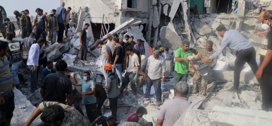
Deadly Strike on Primary School
The bombing of a primary school in the southern Iranian city of Minab on 28 February killed dozens of people, most of them girls aged seven to 12.
The attack on Shajareh Tayyebeh Primary School is the deadliest single incident so far in the war involving Iran, Israel and the United States.
UNESCO has described the strike as a “grave violation” of international law.
Get the latest headlines in your email ![]()
US President Donald Trump has claimed that Iran itself was responsible for the blast, suggesting that an inaccurate Iranian missile caused the destruction.
“In my opinion, based on what I’ve seen, that was done by Iran,” Trump said.
However, he has presented no evidence to support that claim, and US military officials have only said the incident is under investigation.
Meanwhile, open-source analysis — including satellite imagery, geolocation work and weapons fragments — appears to point in another direction.
School Located Near Military Compound
The school stood next to a complex belonging to Iran’s Islamic Revolutionary Guard Corps.
Investigators were able to confirm the exact location by comparing verified videos from the scene with satellite images of the area.
Historical imagery shows the school building had once been part of the wider IRGC compound but had been physically separated from it by walls for at least nine years.
The building also had clear visual features identifying it as a school, including brightly coloured murals and small sports fields.
Although there is no evidence the building itself was used for military purposes, its proximity to the IRGC naval barracks may explain why the surrounding area became a target during the wider air campaign.
Videos Show Strike Near Military Site
Videos posted online shortly after the explosion show the school building reduced to rubble, with thick smoke rising nearby.
Several clips filmed from different angles display distinctive murals that helped investigators confirm the location.
In at least one video, smoke can be seen rising from inside the neighbouring IRGC compound beyond the school’s perimeter wall.
This suggests the school was hit during a wider strike on the military complex next door.
Satellite Images Confirm Multiple Strikes
Satellite imagery released on 4 March showed extensive destruction in the area.
The images revealed the school building completely destroyed, along with four additional buildings located inside the IRGC compound.
The pattern of damage supports the theory that the attack was part of a coordinated strike targeting the military installation.
Missile Identified as Tomahawk
Additional evidence emerged on 8 March when Iranian state media released footage of a missile strike in Minab.
The video was geolocated by the investigative collective Bellingcat, which matched landmarks such as buildings, roads and trees with satellite images to determine where it had been filmed.
The analysis concluded that the missile landed within the IRGC compound adjacent to the school.
Weapons experts identified the projectile in the footage as a Tomahawk cruise missile.
According to munitions specialist N. R. Jenzen-Jones of Armament Research Services, this detail is significant.
“Given the belligerents, that indicates it is a US strike, as Israel is not known to possess Tomahawk missiles,” he said.
The United States is the only country involved in the conflict known to deploy that weapon system.
Missile Fragments Carry US Markings
Iranian media later published photographs of missile fragments allegedly recovered from the bombing site.
The images show pieces of equipment labelled with the logo of Globe Motors and Ball Aerospace, both US defence contractors.
Some fragments also display the words “Made in the USA”.
Analysis reported by the New York Times found that the serial numbers and labelling appeared consistent with US Department of Defense munitions.
Weapons expert Trevor Ball also identified the debris as consistent with components from a Tomahawk missile.
However, the origin of the fragments cannot be independently verified.
Strike Locations in US Briefing
Further evidence comes from a Pentagon briefing on 4 March led by US defence secretary Pete Hegseth.
During the briefing, the US military presented a map showing areas struck during an operation known as Operation Epic Fury.
While Minab was not specifically labelled, one of the marked strike points appears to correspond with the city’s location along Iran’s southern coastline.
Officials have also said that US forces focused their early strikes along southern Iran, while Israeli operations were concentrated in the western part of the country.
Misfire Claims Disputed
Some social media posts have claimed the school was destroyed by a misfired Iranian missile.
However, investigators say the photographs used as evidence for that claim were taken roughly 1,600 kilometres away in the northern Iranian city of Zanjan.
The images show snow-covered mountains in the background, a landscape that does not match the much warmer coastal environment around Minab.
Buildings visible in the photographs were also geolocated to Zanjan.
So far, the US government has not publicly confirmed responsibility for the strike.
But the available evidence — from satellite images to weapons analysis — increasingly suggests the bombing occurred during a US strike targeting nearby military facilities.
Join the discussion? ![]()
Already a member? ![]()
 Adapted by ASEAN Now · Source · 10.03 2026